May 23, 2019
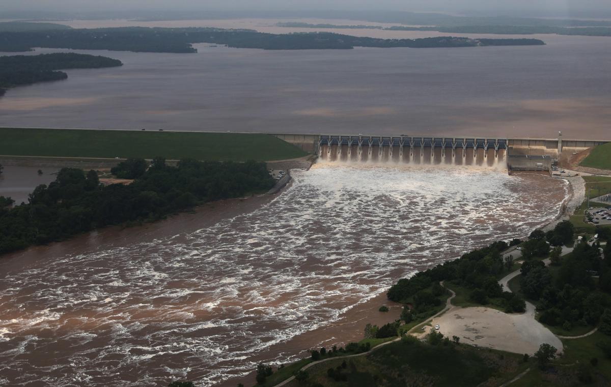
Here in Tulsa, we’re facing flooding on the Arkansas River. Many towns in Eastern and Central Oklahoma are dealing with too much water. My daughter’s school canceled the last 2 days of classes since Keystone Dam is forced to release over 250 cubic feet per second (cps) of water — a controlled flood to try and prevent more damage. For you oil and gas people: that’s 3.84 Billion barrels per day (Bbpd) if it were oil (Thank you, Susan Crenshaw, for the conversion)
Webber’s Falls — 70 miles south — is evacuated, as basically all the water in all the lakes and river tributaries for the eastern half of the state passes by that low-lying community, to join up and head for Arkansas, the Mississippi River and then the Gulf.
One of our problems is we’ve had a very wet Spring, and all the lakes and reservoirs were already full before we got almost a foot of new rain north of Tulsa this week. It’s got to go somewhere once it’s within a lake or river. I wonder whether this is the Global Climate Change New Normal for Oklahoma, or whether our human proclivity for paving everything with concrete increases the runoff, which puts it into those lakes and rivers faster than it used to.
My friend Eric at the Tulsa Area United Way and I discovered some years back that we share a work history — at different times of our lives we helped produce stormwater control maps. Me in Tulsa in 1988, and he in Houston in the 1990s.
You can read lots of history about the pioneering work of the City of Tulsa and Mayor Terry Young back in the late 80s, to say “never again” to catastrophic flooding. I remember going to a friend’s house at 36th & Riverside in 1986 and emptying her house — taking everything and stuffing it in the attic. The City and Corps of Engineers were sure that this section of Tulsa would flood. In the end, the high release of over 305cfs of water “scoured” the deposited sand from the bottom of the riverbed, giving the river the depth to hold more water than projected. It got close to going over its’ banks in this area but thankfully didn’t.
Following the loss of life and property from the 1985-86 flooding, the City condemned or bought property in recurring flood plains, instituted flood insurance in other areas affected by the 100-year flood, and created lots of “impound parks” to slow the water’s journey to the Arkansas River. It has been a great success — many cities have sent teams to examine our success. It’s periodically been covered in the national media. I remember having to not only draw the maps but drive out occasionally to confirm that houses had indeed been removed from areas before we drew it as a new water impound zone.
Eric in Houston, did the same sort of work as I. However in Houston, the high cost of available land made the maps largely irrelevant. People kept building houses and new developments on historic floodplains. You only have to remember pictures of the damage Hurricane Harvey caused to know how that turned out.
Just today (5/23/19), the State of Texas approved $3 Billion in flood control funds for Houston. I can only imagine that Texas legislators in Austin, looking at the news coverage of NE Oklahoma, might have reconsidered any opposition.
As I type, our city flood warning sirens are going off every 30 minutes, letting everyone know about the risk. Our “buffer park” along the river is sacrificing its manicured trails as sinkholes develop, at a lower elevation than most of the roadway. Friends have gone down to Bixby to fill sandbags. The storm sewers in the South Tulsa neighborhood where we rented are starting to back up — 8 houses on that street are in danger. There’s very little altitude difference between them and the river that’s 2 blocks away. I sincerely hope the next few days don’t become another sad story and let’s hope that loss of life won’t be a part of it.
Leave a Reply